For a week and a half this summer, 10 people were doing something most of us would never notice. They were drawing buildings.
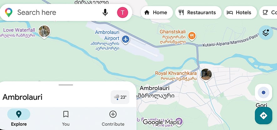
The Georgian OpenStreetMap community was working online with 2025 aerial imagery from the National Agency of Public Registry, tracing buildings, checking roads and adding addresses in Ambrolauri and the surrounding area. The territory was divided into sections so that the volunteers would not overwrite one another’s work. When someone finished a section, they released it for the next person.
It is a strangely modest description of a fairly substantial amount of work. The project resulted in around 18,000 buildings being refined and about 10,000 addresses being added, according to the Georgian OSM community.
The attraction of OpenStreetMap is precisely that its map is not produced in the usual way.
OpenStreetMap is a global database of geographic information maintained by contributors rather than a conventional commercial map product. Its data is openly licensed and can be used by other services and applications. That sounds technical until you consider what a map actually does.
When we look at Google Maps or Apple Maps, we tend to think of the map as an image of a place. In practice, it is a large database of decisions. This is a road; this is a building; this is an address; this path exists; this one does not. A building has a particular footprint. A street has a particular name. A road is classified in one way rather than another. Someone has to make all those decisions.
NAPR supplies the imagery and geographic layers; volunteers interpret, verify and add information; OpenStreetMap makes the resulting data available under an open license
In the Racha project, the starting point was unusually good public data. NAPR had released 2025 orthophotos covering Ambrolauri. An orthophoto is not simply an aerial photograph: it has been geometrically corrected so that objects visible in the image can be positioned and measured more accurately. The OSM project documentation lists NAPR’s orthophoto, cadastral parcels, building footprints, and house-number and street-name layers among the principal sources used by the volunteers. The volunteers then turned that imagery into map data. And this is where the story becomes more interesting than the technology itself.
There is a widespread assumption that detailed geographic information is something that governments and large technology companies naturally produce for us. They have the satellites, aircraft, servers, engineers and enormous amounts of money. The ordinary person is supposed to be the consumer. OpenStreetMap reverses that relationship.
The basic idea behind the project is almost disarmingly simple: if you know something about a place, you can add it to a map that other people can use. The result is not a single authoritative representation produced behind closed doors. It is a constantly edited database.
The Georgian project in Ambrolauri is a particularly clear example because the volunteers were not starting with a blank screen. They were working between several sources of information: aerial imagery, cadastral data, existing OSM information, GPS traces and, where available, street-level imagery. The project documentation is unusually strict about this. It warns contributors not to assume that even high-resolution aerial imagery is perfectly aligned and recommends checking several independent sources before changing the position of existing objects.
That detail says something important about what this kind of volunteer work actually is. It is not simply drawing what you see. It is comparing sources. It is checking whether a line on an aerial photograph corresponds to a road. It is deciding whether a building outline is sufficiently clear to trace. It is refusing to guess an address when the available information is ambiguous. The instructions explicitly tell contributors not to invent an address simply to make the database more complete.
There is a certain intellectual discipline in this kind of work that is easy to miss because the result looks so ordinary. A good digital map hides uncertainty. The screen shows a clean line. The user sees a road, not the question of how confidently that road was identified.
This is one reason the OpenStreetMap model is worth looking at beyond the world of mapping enthusiasts. It belongs to the same family of projects as Wikipedia, open-source software and citizen science, but it has a peculiarity that makes it especially revealing: its subject is the physical world.
A Wikipedia contributor changes a sentence about a historical event. A programmer corrects a piece of code. An OSM contributor changes something that corresponds to an actual place. That makes the map a peculiar meeting point between digital culture and geography. It also changes the old question of who has the authority to describe a territory.
For most of the history of modern cartography, maps were closely connected to states. Governments needed maps for taxation, property registration, infrastructure, administration and military purposes. The cadastral map is perhaps the clearest example: land is divided, identified and assigned information that can have legal and economic consequences.
Producing a reliable map still involves human judgment
The Racha project uses some of this state-produced information, but puts it into a different system. NAPR supplies the imagery and geographic layers; volunteers interpret, verify and add information; OpenStreetMap makes the resulting data available under an open license. It is not a replacement for the public registry. It is something else built partly from the same geographic reality.
A government database and a community map can describe the same building while serving completely different purposes. One may be concerned with property and legal registration. The other may need to know whether there is a usable road next to it, what that road is called, or how a particular path connects to another one. The map becomes useful precisely because different kinds of information can coexist.
This is especially relevant in places where the information people need is not necessarily the information a commercial mapping company has the strongest incentive to maintain.
The Georgian OSM community points out one practical advantage of its data: trails and unpaved roads can be represented even when they are absent from mainstream mapping services. OSM data is used by applications including Organic Maps, CoMaps, OsmAnd, Maps.me, Mapy.com, Wikiloc and Komoot. The data is also used in other contexts in Georgia, including Apple Maps and parts of the country’s public transport information infrastructure.
For someone hiking or driving outside a major city, the difference between a road and a road that actually exists in the database is not philosophical. It is the difference between having information and not having it.
There is another interesting feature of the Racha project: its organization. Ten people did not simply open the map and start editing wherever they liked. The territory was divided into pieces using a Mapping Party Tracker. A contributor claimed a section, worked on it, and released it when finished.
This is a small example of a much larger phenomenon in contemporary knowledge production: collaboration increasingly depends on systems that allow strangers to coordinate without having to know one another.
The participants do not need an office. They do not need a manager standing behind them. They need a shared database, rules, a way to divide the work and a way to check it. The technology is almost secondary. What matters is the social arrangement.
And perhaps this is why the most interesting part of the Racha project is not the number of buildings. Eighteen thousand is impressive, but the number itself tells us relatively little. The more significant fact is that a group of people decided that an existing public resource could be turned into a more detailed and more useful representation of a place, and then spent their own time doing it.
There is no obvious economic transaction at the center of this. Nobody is buying the 18,000 buildings. Nobody is paying 10 people for each address. The contribution enters a common database and may later be used by someone the contributor will never meet. That is an old idea, but the internet has made it unusually scalable.
Public libraries work on a similar principle. So do parks, archives and scientific datasets. Their value does not depend on knowing exactly who will use them next. OpenStreetMap takes this logic into a particularly contemporary territory: the common resource is geographic data.
And because the data can be reused, a small act of editing can have a life beyond the original project. The person tracing a building in Ambrolauri does not need to know which application will eventually display it. The map may appear on a phone, inside a hiking application or in another service that uses OSM data. The contributor’s name disappears. The information remains. There is also a useful corrective here to the popular idea that new technology automatically means less human work.
Much of the technology surrounding maps is extremely automated. Satellites and aircraft produce imagery; software processes enormous datasets; algorithms recognize objects; GPS devices generate tracks. Yet producing a reliable map still involves human judgment.
The OSM documentation for the Racha project is almost a manual for where automation stops being trustworthy. Check the imagery. Compare sources. Do not assume the cadastral boundary is exact. Do not treat one GPS track as absolute truth. Do not guess an address. In other words, the more sophisticated the tools become, the more valuable careful verification can become.
Perhaps that is the most interesting thing happening in Ambrolauri this summer. Not that 10 volunteers have produced a more detailed digital map, but that the production of geographic knowledge is becoming less centralized.
Aerial imagery comes from a state agency. Mapping software is open. The volunteers are independent contributors. The final database can be used by companies, developers, public institutions and ordinary travelers. No single participant owns the whole picture.
The map is assembled from many different kinds of knowledge, and its accuracy depends on how carefully those pieces are put together. That is a very different model from the old image of the cartographer sitting above the landscape and drawing it from a position of authority.
Today, sometimes, the cartographer is simply someone sitting at a computer, looking at an aerial photograph of Ambrolauri and deciding whether that line is actually a road. And then someone else checks it.
By Ivan Nechaev